Marcillac-Saint-Quentin
| Marcillac-Saint-Quentin Marcilhac e Sent Quentin | ||
|---|---|---|
| ||
| Staat | ||
| Region | Nouvelle-Aquitaine | |
| Département (Nr.) | Dordogne (24) | |
| Arrondissement | Sarlat-la-Canéda | |
| Kanton | Sarlat-la-Canéda | |
| Gemeindeverband | Sarlat-Périgord Noir | |
| Koordinaten | 44° 57′ N, 1° 13′ O | |
| Höhe | 121–327 m | |
| Fläche | 16,46 km² | |
| Einwohner | 839 (1. Januar 2022) | |
| Bevölkerungsdichte | 51 Einw./km² | |
| Postleitzahl | 24200 | |
| INSEE-Code | 24252 | |
_mairie.JPG) Rathaus (Mairie) von Marcillac-Saint-Quentin | ||

Marcillac-Saint-Quentin (okzitanisch: Marcilhac e Sent Quentin) ist eine französische Gemeinde mit 839 Einwohnern (Stand: 1. Januar 2022), gelegen im Département Dordogne in der Region Nouvelle-Aquitaine. Die Gemeinde liegt im Arrondissement Sarlat-la-Canéda und zum Kanton Sarlat-la-Canéda.
Geographie
Marcillac-Saint-Quentin liegt in der Landschaft Périgord Noir, etwa 40 Kilometer südöstlich von Périgueux. Umgeben wird Marcillac-Saint-Quentin von den Nachbargemeinden La Chapelle-Aubareil im Norden, Saint-Geniès im Norden und Nordosten, Saint-Crépin-et-Carlucet im Osten, Proissans im Osten und Südosten, Sarlat-la-Canéda im Süden sowie Tamniès im Westen und Nordwesten.
Einwohnerentwicklung
| Jahr | 1962 | 1968 | 1975 | 1982 | 1990 | 1999 | 2006 | 2013 |
| Einwohner | 378 | 406 | 407 | 454 | 598 | 664 | 756 | 786 |
| Quelle: Cassini und INSEE | ||||||||
Sehenswürdigkeiten
- Kirche Saint-Laurent aus dem 16. Jahrhundert
- Kirche Saint-Quentin
- Schloss Lasserre, seit 1926 Monument historique
- Schloss Le Barry
-
_%C3%A9glise_(1).JPG) Kirche Saint-Laurent
Kirche Saint-Laurent -
_%C3%A9glise.JPG) Kirche Saint-Quentin
Kirche Saint-Quentin -
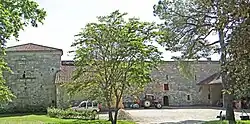 Schloss Lasserre
Weblinks
Commons: Marcillac-Saint-Quentin – Sammlung von Bildern, Videos und Audiodateien