Manitoba Census Division No. 22
| Division No. 22 | |
|---|---|
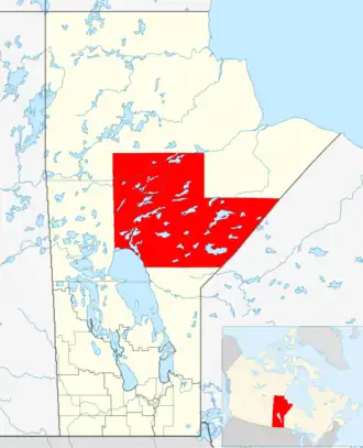 Lage der Region in Manitoba
| |
| Basisdaten | |
| Staat | Kanada |
| Provinz | Manitoba
|
| Koordinaten: | 54° 38′ N, 96° 26′ W |
| Einwohner | 42.165 (Stand: 2016[1]) |
| Fläche | 92.068,5 km² |
| Bevölkerungsdichte | 0,5 Einw./km² |
| Zeitzone: | Central Standard Time (UTC−6) Central Daylight Time (UTC−5, Sommerzeit) |
Die Census Division No. 22 in der kanadischen Provinz Manitoba gehört zur Northern Region. Sie hat eine Fläche von 92.068,5 km² und 42.165 Einwohner (Stand: 2016). 2011 betrug die Einwohnerzahl 40.923.[2]
Census Subdivisions
Im Folgenden die "Census Subdivisions" („Zensus-Untergliederungen“) der Division No. 22 mit Stand vom Census 2016.[3]
- Cross Lake 19 (Indian reserve)
- Cross Lake 19A (Indian reserve)
- Cross Lake 19E (Indian reserve)
- Division No. 22, Unorganized (Unorganized)
- Garden Hill First Nation (Indian reserve)
- God’s Lake 23 (Indian reserve)
- God’s River 86A (Indian reserve)
- Ilford (Indian Settlement)
- Mooseocoot (Indian reserve)
- Mystery Lake (Local government district)
- Nelson House 170 (Indian reserve)
- Norway House 17 (Indian reserve)
- Oxford House 24 (Indian reserve)
- Red Sucker Lake 1976 (Indian reserve)
- Split Lake (Part) 171 (Indian reserve)
- St. Theresa Point (Indian reserve)
- Thompson (City)
- Wasagamack (Indian reserve)
- York Landing (Indian reserve)
Einzelnachweise
- ↑ Statistics Canada: Census Profile, 2016 Census – Division No. 22, Census division (Census division), Manitoba and Alberta (Province), abgerufen am 15. Mai 2021
- ↑ Statistics Canada: Census 2011. Abgerufen am 29. Juli 2012 (englisch).
- ↑ Geographic hierarchy 1: Division No. 22, Census division [Census division[, Manitoba. In: Geographic hierarchies, Census Profile, 2016 Census. Statistics Canada, abgerufen am 20. Juli 2025 (englisch).
Weblinks
- Census Profile: Census Division No. 22, Manitoba; Statistics Canada
- Census Profile: Karte Census Division No. 22, Manitoba; Statistics Canada
Division No. 1 | Division No. 2 | Division No. 3 | Division No. 4 | Division No. 5 | Division No. 6 | Division No. 7 | Division No. 8 | Division No. 9 | Division No. 10 | Division No. 11 | Division No. 12 | Division No. 13 | Division No. 14 | Division No. 15 | Division No. 16 | Division No. 17 | Division No. 18 | Division No. 19 | Division No. 20 | Division No. 21 | | Division No. 23