Villers-sous-Ailly
| Villers-sous-Ailly | ||
|---|---|---|
| ||
| Staat | ||
| Region | Hauts-de-France | |
| Département (Nr.) | Somme (80) | |
| Arrondissement | Abbeville | |
| Kanton | Rue | |
| Gemeindeverband | Ponthieu-Marquenterre | |
| Koordinaten | 50° 4′ N, 2° 1′ O | |
| Höhe | 40–112 m | |
| Fläche | 6,26 km² | |
| Einwohner | 174 (1. Januar 2022) | |
| Bevölkerungsdichte | 28 Einw./km² | |
| Postleitzahl | 80690 | |
| INSEE-Code | 80804 | |
.JPG) Rathaus- und Schulgebäude | ||

Villers-sous-Ailly (picardisch: Vilèr-dsous-Ailly) ist eine nordfranzösische Gemeinde mit 174 Einwohnern (Stand 1. Januar 2022) im Département Somme in der Region Hauts-de-France. Die Gemeinde liegt im Arrondissement Abbeville und ist Teil der Communauté de communes Ponthieu-Marquenterre und des Kantons Rue.
Geographie
Die zwischen der ehemaligen Route nationale 35 und der Autoroute A16 in einem Trockental gelegene Gemeinde schließt unmittelbar südöstlich an das Gebiet von Ailly-le-Haut-Clocher an.
Einwohner
| 1962 | 1968 | 1975 | 1982 | 1990 | 1999 | 2006 | 2011 |
|---|---|---|---|---|---|---|---|
| 142 | 143 | 109 | 122 | 146 | 146 | 176 | 189 |
Sehenswürdigkeiten
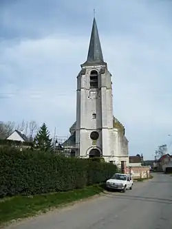
- Kirche Saint-Aubin[1]
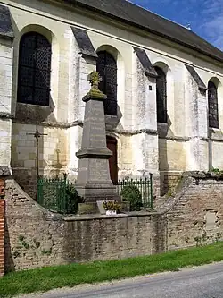
- Kriegerdenkmal
Einzelnachweise
Weblinks
Commons: Villers-sous-Ailly – Sammlung von Bildern, Videos und Audiodateien