Villepot
| Villepot Kerbod | ||
|---|---|---|
.svg.png)
|
| |
| Staat | ||
| Region | Pays de la Loire | |
| Département (Nr.) | Loire-Atlantique (44) | |
| Arrondissement | Châteaubriant-Ancenis | |
| Kanton | Châteaubriant | |
| Gemeindeverband | Châteaubriant-Derval | |
| Koordinaten | 47° 47′ N, 1° 17′ W | |
| Höhe | 66–116 m | |
| Fläche | 20,59 km² | |
| Einwohner | 687 (1. Januar 2022) | |
| Bevölkerungsdichte | 33 Einw./km² | |
| Postleitzahl | 44110 | |
| INSEE-Code | 44218 | |
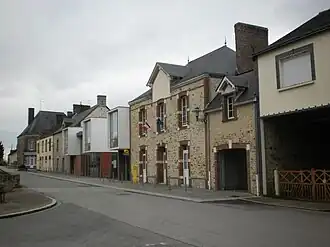 Rathaus (Mairie) von Villepot | ||

Villepot (bretonisch: Kerbod) ist eine französische Gemeinde mit 687 Einwohnern (Stand: 1. Januar 2022) im Département Loire-Atlantique in der Region Pays de la Loire; sie gehört zum Arrondissement Châteaubriant-Ancenis und zum Kanton Châteaubriant. Die Einwohner werden Villepotais genannt.
Geographie
Villepot liegt etwa 65 Kilometer nordnordöstlich von Nantes am Fluss Brutz. Umgeben wird Villepot von den Nachbargemeinden Martigné-Ferchaud im Norden, Pouancé im Osten, Carbay im Südosten, Soudan im Süden sowie Noyal-sur-Brutz im Westen.
Bevölkerungsentwicklung
| Jahr | 1962 | 1968 | 1975 | 1982 | 1990 | 1999 | 2006 | 2017 |
| Einwohner | 835 | 770 | 700 | 649 | 690 | 668 | 687 | 669 |
| Quellen: Cassini und INSEE | ||||||||
Sehenswürdigkeiten
- Kirche Notre-Dame aus dem 15. Jahrhundert
- Kapelle Notre-Dame-de-Bon-Secours aus der Revolutionszeit

Literatur
- Le Patrimoine des Communes de la Loire-Atlantique. Flohic Editions, Band 2, Charenton-le-Pont 1999, ISBN 2-84234-040-X, S. 1032–1034.
Weblinks
Commons: Villepot – Sammlung von Bildern, Videos und Audiodateien