Villeneuve-lès-Bouloc
| Villeneuve-lès-Bouloc | ||
|---|---|---|

|
| |
| Staat | ||
| Region | Okzitanien | |
| Département (Nr.) | Haute-Garonne (31) | |
| Arrondissement | Toulouse | |
| Kanton | Villemur-sur-Tarn | |
| Gemeindeverband | Frontonnais | |
| Koordinaten | 43° 46′ N, 1° 26′ O | |
| Höhe | 113–217 m | |
| Fläche | 12,66 km² | |
| Einwohner | 1.687 (1. Januar 2022) | |
| Bevölkerungsdichte | 133 Einw./km² | |
| Postleitzahl | 31620 | |
| INSEE-Code | 31587 | |
 Kirche Saint-Pierre | ||

Villeneuve-lès-Bouloc ist eine französische Gemeinde mit 1.687 Einwohnern (Stand 1. Januar 2022) im Département Haute-Garonne in der Region Okzitanien. Sie gehört zum Arrondissement Toulouse und zum Kanton Villemur-sur-Tarn.
Geographie
Villeneuve-lès-Bouloc liegt in Südfrankreich. Nördlich der Gemeinde liegt Bouloc, östlich Vacquiers, südlich Cépet und westlich Saint-Sauveur.
Bevölkerungsentwicklung
| Jahr | 1962 | 1968 | 1975 | 1982 | 1990 | 1999 | 2008 | 2017 |
| Einwohner | 406 | 429 | 583 | 699 | 882 | 950 | 1028 | 1622 |
| Quellen: Cassini und INSEE | ||||||||
Sehenswürdigkeiten
- Château de Villefranche (Schloss)
- Kirche Saint-Pierre
-
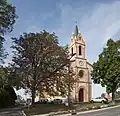 Die Kirche vom Eingang aus betrachtet
 -
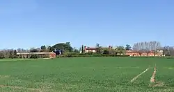 Château de Villefranche
Literatur
- Le Patrimoine des Communes de la Haute-Garonne. Flohic Editions, Band 1, Paris 2000, ISBN 2-84234-081-7, S. 736–737.
Weblinks
Commons: Villeneuve-lès-Bouloc – Sammlung von Bildern, Videos und Audiodateien