Tysons
| Tysons | |
|---|---|
 | |
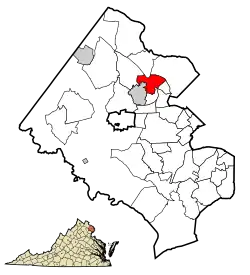
| Lage von Tysons im Fairfax County | |
 | |
| Basisdaten | |
| Staat: | Vereinigte Staaten |
| Bundesstaat: | Virginia |
| County: | Fairfax County |
| Koordinaten: | 38° 55′ N, 77° 14′ W |
| Zeitzone: | Eastern (UTC−5/−4) |
| Einwohner: | 26.374 (Stand: 2020) |
| Haushalte: | 11.874 (Stand: 2020) |
| Fläche: | 12,7 km2 (ca. 5 mi²) davon 12,7 km2 (ca. 5 mi²) Land |
| Bevölkerungsdichte: | 2.077 Einwohner je km2 |
| Höhe: | 148 m |
| Postleitzahlen: | 22102, 22182 |
| FIPS: | 51-79950 |
| GNIS-ID: | 1496341 |
Tysons ist ein Ort (CDP) im Fairfax County des US-Bundesstaats Virginia nahe Washington, D.C.[1] Das U.S. Census Bureau hat bei der Volkszählung 2020 eine Einwohnerzahl von 26.374[2] ermittelt.
Tysons liegt am Interstate 495 (Capital Beltway). Umliegende Ortschaften sind McLean, Pimmit Hills und Vienna.
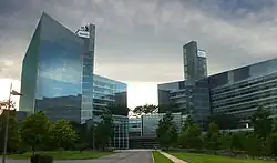
Wirtschaft
Tysons ist das wirtschaftliche Zentrum des Fairfax County, sowohl als Büro-Standort, als auch zum Einkaufen – eine sogenannte Edge City. Einige bedeutende Unternehmen haben daher ihren Hauptsitz in Tysons, darunter:
- Alion Science and Technology
- Booz Allen Hamilton
- Capital One
- Freddie Mac
- Gannett
- Hilton Worldwide
- Iridium Communications Inc. (Betreiber des Satellitenkommunikationssystems Iridium)
- Science Applications International Corporation
- Sunrise Senior Living
Weblinks
Commons: Tysons Corner – Sammlung von Bildern
Wikivoyage: Tysons Corner – Reiseführer
Wiktionary: Tysons – Bedeutungserklärungen, Wortherkunft, Synonyme, Übersetzungen
Einzelnachweise
- ↑ Tysons. In: Geographic Names Information System. United States Geological Survey, United States Department of the Interior, abgerufen am 5. September 2024 (englisch).
- ↑ US Census Bureau: Search Results Total Population in Tysons CDP, Virginia. Abgerufen am 12. Mai 2024 (amerikanisches Englisch).