Saulmory-Villefranche
| Saulmory-Villefranche | ||
|---|---|---|
.svg.png)
|
| |
| Staat | ||
| Region | Grand Est | |
| Département (Nr.) | Meuse (55) | |
| Arrondissement | Verdun | |
| Kanton | Stenay | |
| Gemeindeverband | Pays de Stenay et du Val Dunois | |
| Koordinaten | 49° 26′ N, 5° 11′ O | |
| Höhe | 167–200 m | |
| Fläche | 6,85 km² | |
| Einwohner | 82 (1. Januar 2022) | |
| Bevölkerungsdichte | 12 Einw./km² | |
| Postleitzahl | 55110 | |
| INSEE-Code | 55471 | |
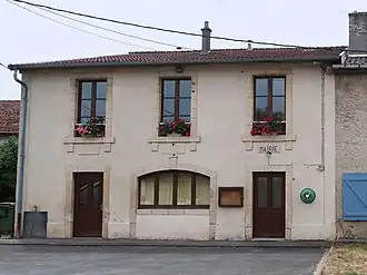 Mairie Saulmory-Villefranche | ||

Saulmory-Villefranche (früher: Saulmory-et-Villefranche) ist eine französische Gemeinde mit 82 Einwohnern (Stand: 1. Januar 2022) im Département Meuse in der Region Grand Est (vor 2016: Lothringen). Die Gemeinde gehört zum Arrondissement Verdun, zum Kanton Stenay und zum Gemeindeverband Pays de Stenay et du Val Dunois.
Geographie
Saulmory-Villefranche liegt etwa 48 Kilometer nordnordwestlich von Verdun an der Maas, die die Gemeinde im Osten begrenzt. Umgeben wird Saulmory-Villefranche von den Nachbargemeinden Wiseppe im Norden, Stenay im Nordosten, Mouzay im Nordosten und Osten, Mont-devant-Sassey im Süden sowie Montigny-devant-Sassey im Südwesten und Westen.
Bevölkerungsentwicklung
| Jahr | 1962 | 1968 | 1975 | 1982 | 1990 | 1999 | 2006 | 2011 | 2019 |
| Einwohner | 135 | 117 | 120 | 117 | 117 | 102 | 106 | 106 | 83 |
| Quellen: Cassini und INSEE | |||||||||
Sehenswürdigkeiten
- Kirche Saint-Denis in Saulmory aus dem 13. Jahrhundert
- Kirche Saint-Denis in Villefranche aus dem Jahre 1895
-
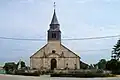 Kirche Saint-Denis in Saulmory
 -
 Kirche Saint-Denis in Villefranche
Literatur
- Le Patrimoine des Communes de la Meuse. Flohic Editions, Band 1, Paris 1999, ISBN 2-84234-074-4, S. 372–374.
Weblinks
Commons: Saulmory-Villefranche – Sammlung von Bildern, Videos und Audiodateien