Notoue
| Nooto Notoue | |||
|---|---|---|---|
| |||
| Koordinaten | 1° 31′ 12″ N, 173° 0′ 11″ O | ||
| Basisdaten | |||
| Staat | Kiribati | ||
| Inselgruppe | Gilbertinseln | ||
| Fläche | 0,5 km² | ||
| Einwohner | 811 (2020) | ||
| Dichte | 1.655,1 Ew./km² | ||
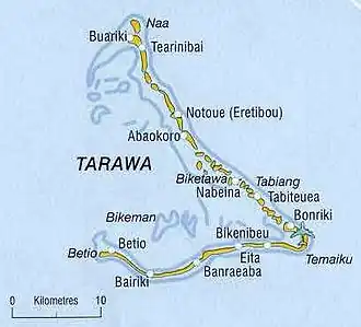 | |||
Notoue (offiziell verwendete Schreibweise: Nooto, auch Nootoue oder Nootouee, früher Eretiboou[1]) ist ein Ort mit einer Landfläche von 0,49 km²[2] im Nordosten des Tarawa-Atolls in den zum Inselstaat Kiribati gehörenden Gilbertinseln im Pazifischen Ozean. 2020 hatte der Ort 811 Einwohner.[3]
Geographie
Der Ort Notoue liegt auf dem gleichnamigen Motu im Nordosten von Tarawa.[4] Es gibt mehrere Kirchen und Versammlungshäuser. Der Ortsteil Taborio ist Standort des katholischen Immaculate Heart College,[5] der einzigen Senior High School von North Tarawa.
Das Motu Notoue mit einer Fläche von rund 1,13 km²[6] ist Teil des nordöstlichen Arms des Atolls von Tarawa und durch Landbrücken mit den benachbarten Motus verbunden. Nur schmale Kanäle schneiden die Riffkrone ein. Die Straßenverbindung nach Norden verläuft über einen Damm.[7]
Über Notoue und die angrenzenden Gebiete im Norden erstreckt sich ein Ramsar-Naturschutzgebiet.[8]
Klima
Das Klima ist tropisch heiß, wird jedoch von ständig wehenden Winden gemäßigt. Ebenso wie die anderen Orte des Tarawa-Atolls wird Notoue gelegentlich von Zyklonen heimgesucht.
Einzelnachweise
- ↑ Republic of Kiribati – Ministry of Internal and Social Affairs (Hrsg.): North Tarawa 2008 Socio-Economic Profile. Band 1, 2008, 2.1.5: History and Culture, S. 16 (englisch, climate.gov.ki [PDF; 1,1 MB; abgerufen am 30. Juli 2024]).
- ↑ Republic of Kiribati – Ministry of Internal and Social Affairs (Hrsg.): North Tarawa 2008 Socio-Economic Profile. Band 1, 2008, Table 1: North Tarawa Population Density by village (2000 & 2005), S. 19 (englisch, climate.gov.ki [PDF; 1,1 MB; abgerufen am 30. Juli 2024]).
- ↑ Kiribati – Population and Housing Census 2020. Value 606. In: microdata.pacificdata.org. Pazifische Gemeinschaft, 25. Juni 2024, abgerufen am 3. September 2024 (englisch).
- ↑ Republic of Kiribati – Office of Te Beretitenti (Hrsg.): North Tarawa (= Republic of Kiribati Island Report Series. Nr. 5). 2012, Figure 5.1: Map of North Tarawa, S. 3 (englisch, climate.gov.ki [PDF; 533 kB; abgerufen am 30. Juli 2024]).
- ↑ Republic of Kiribati – Ministry of Internal and Social Affairs (Hrsg.): North Tarawa 2008 Socio-Economic Profile. Band 1, 2008, 3.1.4: Breakdown of Population, S. 22 (englisch, climate.gov.ki [PDF; 1,1 MB; abgerufen am 30. Juli 2024]).
- ↑ Aritita Tekaieti, Tekena Tiroa; Republic of Kiribati – National Statistics Office, Ministry of Finance and Economic Planning (Hrsg.): Report on the Kiribati 2010 Census of Population and Housing – Vol 1: Basic Information and Tables. August 2012, Appendix 5: Land Area of islands in Kiribati, S. 221–227, hier: S. 223 (englisch, mfed.gov.ki [PDF; 6,7 MB; abgerufen am 30. Juli 2024]).
- ↑ Notoue und Notoue (Dorf). GeoNames.org; abgerufen am 16. Oktober 2020.
- ↑ Map of Tarawa atoll Kiribati locating the Nooto Ramsar site and locations of spatial fig 1. Assessing atoll shoreline condition to guide community management. researchgate.net; abgerufen am 16. Oktober 2020.