Maatsuyker-Inseln
| Maatsuyker-Inseln | ||
|---|---|---|
 | ||
| Gewässer | Pazifischer Ozean | |
| Geographische Lage | 43° 38′ S, 146° 18′ O | |
| ||
| Anzahl der Inseln | 6 (+ 2 Felsgruppen) | |
| Hauptinsel | Maatsuyker Island | |
| Gesamte Landfläche | 8 km² | |
| Einwohner | unbewohnt | |
 | ||
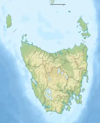
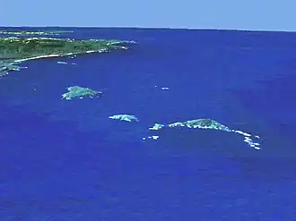
Die Maatsuyker-Inseln sind eine zum australischen Bundesstaat Tasmania gehörende Inselgruppe im Südpazifik. Sie liegen nur wenige Kilometer vor der Südküste der Insel Tasmanien.
Geographie
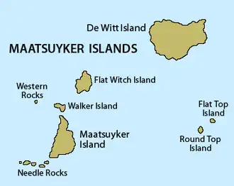
Zur Gruppe, die sich von Nordost nach Südwest über etwa 13 Kilometer Luftlinie erstreckt, gehören sechs kleine Inseln und zwei Felsinselgruppen:
| Inselname | Aliasname | Koordinaten | Fläche | Einwohner | Anmerkung |
|---|---|---|---|---|---|
| De Witt Island | 43° 36′ S, 146° 21′ O | 5,17 | - | ||
| Flat Witch Island | 43° 37′ S, 146° 17′ O | 0,64 | - | ||
| Walker Island | 43° 38′ S, 146° 16′ O | 0,15 | - | ||
| Western Rocks | 43° 38′ S, 146° 19′ O | 0,01 | - | Inselgruppe | |
| Flat Top Island | 43° 38′ S, 146° 23′ O | 0,01 | - | ||
| Round Top Island | 43° 39′ S, 146° 22′ O | 0,01 | - | ||
| Maatsuyker Island | 43° 39′ S, 146° 17′ O | 1,86 | - | ||
| Needle Rocks | 43° 40′ S, 146° 15′ O | 0,15 | - | Inselgruppe |
Mitunter werden, obwohl weit abgelegen, hinzugezählt: die Breaksea Islands, Eddystone Rock, Kathleen Islands, Mewstone, Pedra Branca, Shanks Islands sowie die Trumpeter-Inseln.
Nutzung
Lediglich auf der Hauptinsel Maatsuyker Island befinden sich Bauten, ein heute automatisch betriebener Leuchtturm und eine unbemannte Wetterstation sowie ein kleiner Hubschrauberlandeplatz.
Die Inseln sind Teil des Southwest-Nationalparks von Tasmanien.
Weblinks
- Leuchtturm und Wetterstation auf Maatsuyker Island (bebildert, engl.)