Louppy-le-Château
| Louppy-le-Château | ||
|---|---|---|

|
| |
| Staat | ||
| Region | Grand Est | |
| Département (Nr.) | Meuse (55) | |
| Arrondissement | Bar-le-Duc | |
| Kanton | Kanton Revigny-sur-Ornain | |
| Gemeindeverband | L’Aire à l’Argonne | |
| Koordinaten | 48° 52′ N, 5° 5′ O | |
| Höhe | 163–232 m | |
| Fläche | 18,76 km² | |
| Einwohner | 163 (1. Januar 2022) | |
| Bevölkerungsdichte | 9 Einw./km² | |
| Postleitzahl | 55800 | |
| INSEE-Code | 55304 | |

Louppy-le-Château [] ist eine französische Gemeinde im Département Meuse in der Region Grand Est. Sie hat eine Fläche von 19,02 km² und 163 Einwohner (2022).
Geografie
Die Gemeinde Louppy-le-Château liegt an der Chée, zwölf Kilometer nordwestlich von Bar-le-Duc.
Bevölkerungsentwicklung
| Jahr | 1962 | 1968 | 1975 | 1982 | 1990 | 1999 | 2004 | 2009 | 2019 |
|---|---|---|---|---|---|---|---|---|---|
| Einwohner | 166 | 170 | 159 | 165 | 180 | 171 | 167 | 168 | 159 |
| Quellen: Cassini und INSEE | |||||||||
Sehenswürdigkeiten
- Kirche Saint-Timothée-Saint-Apollinaire, erbaut im 12. Jahrhundert
- Friedhofskapelle
-
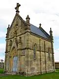 Friedhofskapelle
 -
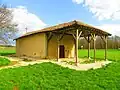 Kapelle Sainte-Anne
Literatur
- Le Patrimoine des Communes de la Meuse. Flohic Editions, Band 2, Paris 1999, ISBN 2-84234-074-4, S. 1009–1011.
Weblinks
Commons: Louppy-le-Château – Sammlung von Bildern, Videos und Audiodateien