Loreux
| Loreux | ||
|---|---|---|
| ||
| Staat | ||
| Region | Centre-Val de Loire | |
| Département (Nr.) | Loir-et-Cher (41) | |
| Arrondissement | Romorantin-Lanthenay | |
| Kanton | Romorantin-Lanthenay | |
| Gemeindeverband | Romorantinais et du Monestois | |
| Koordinaten | 47° 24′ N, 1° 50′ O | |
| Höhe | 88–124 m | |
| Fläche | 29,95 km² | |
| Einwohner | 224 (1. Januar 2022) | |
| Bevölkerungsdichte | 7 Einw./km² | |
| Postleitzahl | 41200 | |
| INSEE-Code | 41118 | |

Loreux ist eine französische Gemeinde mit 224 Einwohnern (Stand: 1. Januar 2022) im Département Loir-et-Cher der Region Centre-Val de Loire. Sie gehört zum Arrondissement Romorantin-Lanthenay und zum Kanton Romorantin-Lanthenay.
Geographie
Die Gemeinde Loreux liegt etwa 43 Kilometer südöstlich von Blois und etwa acht Kilometer nordöstlich des Stadtzentrums von Romorantin-Lanthenay in der Seenlandschaft Sologne. Im Süden der Gemeinde fließt die Sauldre. Umgeben wird Loreux von den Nachbargemeinden Millançay im Norden und Westen, Marcilly-en-Gault im Norden und Nordosten, Selles-Saint-Denis im Osten sowie Villeherviers im Süden und Westen.
Bevölkerungsentwicklung
| Jahr | 1962 | 1968 | 1975 | 1982 | 1990 | 1999 | 2006 | 2012 | 2022 |
|---|---|---|---|---|---|---|---|---|---|
| Einwohner | 339 | 285 | 247 | 260 | 265 | 255 | 248 | 230 | 224 |
| Quellen: Cassini und INSEE | |||||||||
Sehenswürdigkeiten
- Kirche Saint-Laurian
- Schloss Villechaise
- Schloss La Gravellière
- Schloss Villeloup
-
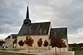 Kirche Saint-Laurian
 -
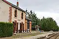 Ehemaliger Bahnhof
 -
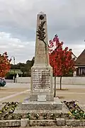 Gefallenendenkmal
Weblinks
Commons: Loreux – Sammlung von Bildern