La Mancelière
| La Mancelière | ||
|---|---|---|
| ||
| Staat | ||
| Region | Centre-Val de Loire | |
| Département (Nr.) | Eure-et-Loir (28) | |
| Arrondissement | Dreux | |
| Kanton | Saint-Lubin-des-Joncherets | |
| Gemeindeverband | Agglo du Pays de Dreux | |
| Koordinaten | 48° 39′ N, 1° 0′ O | |
| Höhe | 179–212 m | |
| Fläche | 5,9 km² | |
| Einwohner | 152 (1. Januar 2022) | |
| Bevölkerungsdichte | 26 Einw./km² | |
| Postleitzahl | 28270 | |
| INSEE-Code | 28231 | |
_Montmureau_mairie_Eure-et-Loir_France.jpg) Mairie La Mancelière | ||

La Mancelière ist eine französische Gemeinde mit 152 Einwohnern (Stand: 1. Januar 2022) im Département Eure-et-Loir in der Region Centre-Val de Loire; sie gehört zum Arrondissement Dreux und zum Kanton Saint-Lubin-des-Joncherets.
Geographie
La Mancelière liegt etwa 45 Kilometer nordwestlich von Chartres. Umgeben wird La Mancelière von den Nachbargemeinden Beauche im Norden, Les Châtelets im Nordosten und Osten, La Saucelle im Osten und Südosten, La Puisaye im Süden sowie Morvilliers im Westen.
Bevölkerungsentwicklung
| Jahr | 1962 | 1968 | 1975 | 1982 | 1990 | 1999 | 2026 | 2020 |
| Einwohner | 148 | 127 | 102 | 117 | 134 | 142 | 158 | 169 |
| Quellen: Cassini und INSEE | ||||||||
Sehenswürdigkeiten
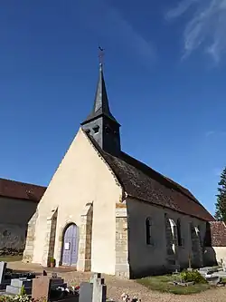
- Kirche Notre-Dame
Weblinks
Commons: La Mancelière – Sammlung von Bildern