Kanton Mélisey
| Kanton Mélisey | |
|---|---|
| Region | Bourgogne-Franche-Comté |
| Département | Haute-Saône |
| Arrondissement | Lure |
| Hauptort | Mélisey |
| Einwohner | 10.677 (1. Jan. 2022) |
| Bevölkerungsdichte | 26 Einw./km² |
| Fläche | 415,58 km² |
| Gemeinden | 33 |
| INSEE-Code | 7010 |
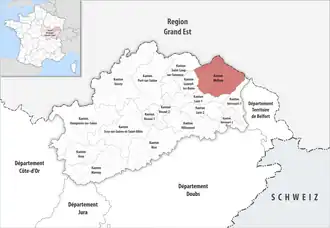 Lage des Kantons Mélisey im Département Haute-Saône | |
Der Kanton Mélisey ist seit 1803 ein französischer Wahlkreis im Arrondissement Lure im Département Haute-Saône in der Region Bourgogne-Franche-Comté. Sein Hauptort ist Mélisey.
Gemeinden
Der Kanton besteht aus 33 Gemeinden mit insgesamt 10.677 Einwohnern (Stand: 1. Januar 2022) auf einer Gesamtfläche von 415,58 km²:
| Gemeinde | Einwohner 1. Januar 2022 |
Fläche km² |
Dichte Einw./km² |
Code INSEE |
Postleitzahl |
|---|---|---|---|---|---|
| Amage | 305 | 6,54 | 47 | 70011 | 70280 |
| Amont-et-Effreney | 166 | 16,83 | 10 | 70016 | 70310 |
| Belfahy | 84 | 3,07 | 27 | 70061 | 70280 |
| Belmont | 141 | 4,50 | 31 | 70062 | 70270 |
| Belonchamp | 207 | 6,87 | 30 | 70063 | 70280 |
| Beulotte-Saint-Laurent | 61 | 14,20 | 4 | 70071 | 70310 |
| Breuchotte | 301 | 4,37 | 69 | 70094 | 70280 |
| Corravillers | 164 | 11,20 | 15 | 70176 | 70310 |
| Écromagny | 150 | 6,80 | 22 | 70210 | 70270 |
| Esmoulières | 97 | 20,11 | 5 | 70217 | 70310 |
| Faucogney-et-la-Mer | 446 | 14,14 | 32 | 70227 | 70310 |
| Fresse | 695 | 27,15 | 26 | 70256 | 70270 |
| Haut-du-Them-Château-Lambert | 448 | 25,16 | 18 | 70283 | 70440 |
| La Bruyère | 169 | 6,32 | 27 | 70103 | 70280 |
| La Corbière | 110 | 3,15 | 35 | 70172 | 70300 |
| La Lanterne-et-les-Armonts | 196 | 9,89 | 20 | 70295 | 70270 |
| La Longine | 196 | 12,40 | 16 | 70308 | 70310 |
| La Montagne | 38 | 12,61 | 3 | 70352 | 70310 |
| La Proiselière-et-Langle | 145 | 7,06 | 21 | 70425 | 70310 |
| La Rosière | 79 | 9,00 | 9 | 70453 | 70310 |
| La Voivre | 109 | 11,87 | 9 | 70573 | 70310 |
| Les Fessey | 129 | 5,54 | 23 | 70233 | 70310 |
| Lantenot | 362 | 8,26 | 44 | 70294 | 70200 |
| Magnivray | 164 | 4,76 | 34 | 70314 | 70300 |
| Mélisey | 1.643 | 20,67 | 79 | 70339 | 70270 |
| Montessaux | 170 | 3,05 | 56 | 70361 | 70270 |
| Raddon-et-Chapendu | 852 | 12,50 | 68 | 70435 | 70280 |
| Rignovelle | 121 | 4,37 | 28 | 70445 | 70200 |
| Saint-Barthélemy | 1.091 | 13,46 | 81 | 70459 | 70270 |
| Saint-Bresson | 420 | 26,60 | 16 | 70460 | 70280 |
| Sainte-Marie-en-Chanois | 209 | 4,79 | 44 | 70469 | 70310 |
| Servance-Miellin | 764 | 52,60 | 15 | 70489 | 70440 |
| Ternuay-Melay-et-Saint-Hilaire | 445 | 25,74 | 17 | 70498 | 70270 |
| Kanton Mélisey | 10.677 | 415,58 | 26 | 7010 | – |
Bis zur landesweiten Neuordnung der französischen Kantone im März 2015 gehörten zum Kanton Mélisey die 13 Gemeinden Belfahy, Belmont, Belonchamp, Écromagny, Fresse, Haut-du-Them-Château-Lambert, La Lanterne-et-les-Armonts, Mélisey, Miellin, Montessaux, Saint-Barthélemy, Servance und Ternuay-Melay-et-Saint-Hilaire. Sein Zuschnitt entsprach einer Fläche von 198,96 km km2. Er besaß vor 2015 einen anderen INSEE-Code als heute, nämlich 7016.
Veränderungen im Gemeindebestand seit der landesweiten Neuordnung der Kantone
2017: Fusion Miellin und Servance → Servance-Miellin
Bevölkerungsentwicklung
| Jahr | 1962 | 1968 | 1975 | 1982 | 1990 | 1999 | |||
|---|---|---|---|---|---|---|---|---|---|
| Einwohner | 6.821 | 7.549 | 7.249 | 6.992 | 6.509 | 6.198 | |||
| Quellen: Cassini und INSEE | |||||||||