Fromont
| Fromont | ||
|---|---|---|
| ||
| Staat | ||
| Region | Île-de-France | |
| Département (Nr.) | Seine-et-Marne (77) | |
| Arrondissement | Fontainebleau | |
| Kanton | Fontainebleau | |
| Gemeindeverband | Pays de Nemours | |
| Koordinaten | 48° 15′ N, 2° 30′ O | |
| Höhe | 107–142 m | |
| Fläche | 10,72 km² | |
| Einwohner | 230 (1. Januar 2022) | |
| Bevölkerungsdichte | 21 Einw./km² | |
| Postleitzahl | 77760 | |
| INSEE-Code | 77198 | |
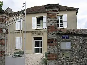 Mairie (Rathaus) | ||

Fromont ist eine französische Gemeinde mit 230 Einwohnern (Stand: 1. Januar 2022) im Département Seine-et-Marne in der Region Île-de-France. Sie gehört zum Arrondissement Fontainebleau und zum Kanton Fontainebleau.
Geographie
Fromont liegt auf einem Hügel sieben Kilometer nordöstlich von Puiseaux, einen Kilometer südlich von Rumont und neun Kilometer südwestlich von La Chapelle-la-Reine im Regionalen Naturpark Gâtinais français.
Nachbargemeinden
| Boulancourt | Rumont | Amponville |
.svg.png)
|
Guercheville | |
| Orville | Desmonts | Burcy |
Sehenswürdigkeiten
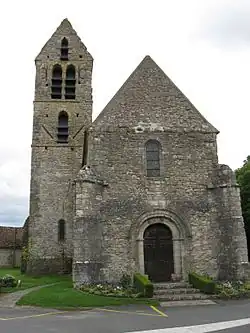
- Kirche Saint-Martin (Monument historique)
Literatur
- Le Patrimoine des Communes de la Seine-et-Marne. Flohic Editions, Band 1, Paris 2001, ISBN 2-84234-100-7, S. 148–150.
Weblinks
Commons: Fromont – Sammlung von Bildern, Videos und Audiodateien