Froidmont-Cohartille
| Froidmont-Cohartille | ||
|---|---|---|
| ||
| Staat | ||
| Region | Hauts-de-France | |
| Département (Nr.) | Aisne (02) | |
| Arrondissement | Laon | |
| Kanton | Marle | |
| Gemeindeverband | Pays de la Serre | |
| Koordinaten | 49° 41′ N, 3° 43′ O | |
| Höhe | 62–107 m | |
| Fläche | 8,81 km² | |
| Einwohner | 246 (1. Januar 2022) | |
| Bevölkerungsdichte | 28 Einw./km² | |
| Postleitzahl | 02270 | |
| INSEE-Code | 02338 | |

Froidmont-Cohartille ist eine französische Gemeinde mit 246 Einwohnern (Stand: 1. Januar 2022) im Département Aisne der Region Hauts-de-France (bis 2015: Picardie). Sie gehört zum Arrondissement Laon, zum Kanton Marle und zum Gemeindeverband Pays de la Serre.
Lage
Die Gemeinde Froidmont-Cohartille liegt im Südwesten der Thiérache am Fluss Souche, 16 Kilometer nordnordöstlich von Laon.. Umgeben wird Froidmont-Cohartille von den Nachbargemeinden Voyenne im Norden, Toulis-et-Attencourt im Nordosten, Grandlup-et-Fay im Südosten, Barenton-sur-Serre im Südwesten sowie Dercy im Nordwesten.
Bevölkerungsentwicklung
| Jahr | 1962 | 1968 | 1975 | 1982 | 1990 | 1999 | 2006 | 2014 | 2021 |
| Einwohner | 327 | 278 | 251 | 240 | 234 | 209 | 190 | 262 | 248 |
| Quellen: Cassini und INSEE | |||||||||
Sehenswürdigkeiten
- Kirche Saint-Christophe
- Kirche Saint-Martin
- Wasserturm
-
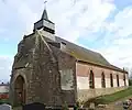 Kirche Saint-Christophe
 -
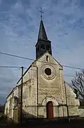 Kirche Saint-Martin
 -
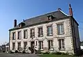 Mairie Froidmont-Cohartille
Weblinks
Commons: Froidmont-Cohartille – Sammlung von Bildern