Flughafen Port Moresby
| Port Moresby International Airport | |||
|---|---|---|---|
 | |||
| |||
| Kenndaten | |||
| ICAO-Code | AYPY | ||
| IATA-Code | POM | ||
| Koordinaten | 9° 26′ 36″ S, 147° 13′ 12″ O | ||
| Höhe über MSL | 38 m (125 ft) | ||
| Verkehrsanbindung | |||
| Entfernung vom Stadtzentrum | 8 km nordöstlich von Port Moresby | ||
| Basisdaten | |||
| Betreiber | Papua New Guinea Office Of Civil Aviation | ||
| Terminals | 2 | ||
| Passagiere | 840.000 | ||
| Start- und Landebahnen | |||
| 14L/32R | 2750 m × 45 m Asphalt | ||
| 14R/32L | 2072 m × 45 m Asphalt | ||
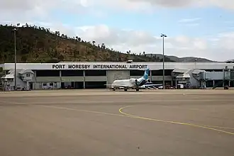
Der Port Moresby International Airport (IATA-Code: POM, ICAO-Code: AYPY), auch Jacksons International Airport oder Port Moresby Airport[1][2], liegt nahe der Stadt Port Moresby und ist der größte und verkehrsreichste Flughafen in Papua-Neuguinea.
Am Flughafen hat die nationale Fluglinie Air Niugini ihre Heimatbasis und ihr Drehkreuz. Zudem fliegt Airlines PNG innerhalb von Papua-Neuguinea sowie nach Australien.
Weblinks
Einzelnachweise
- ↑ Certified Aerodromes. Civil Aviation Safety Authority. Abgerufen am 10. Februar 2016
- ↑ Port Moresby International Airport (Jacksons). National Airports Corporation, 24. März 2011 ( vom 27. Oktober 2012 im Internet Archive)