Desolation Island (Südliche Shetlandinseln)
| Desolation Island
| ||
|---|---|---|
 | ||
| Gewässer | Hero Bay, Drakestraße | |
| Inselgruppe | Südlichen Shetlandinseln | |
| Geographische Lage | 62° 27′ S, 60° 21′ W | |
| ||
| Höchste Erhebung | Burel Hill 152 m | |
| Einwohner | unbewohnt | |
 | ||
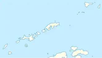
Desolation Island (von englisch desolation ‚Trostlosigkeit, Ödnis‘, in Chile Isla Desolación) ist eine v-förmige Insel im Archipel der Südlichen Shetlandinseln. Sie liegt im Osten der Einfahrt der Hero Bay vor der Nordküste der Livingston-Insel in einer Entfernung von 8 km westlich zum Williams Point.
Entdeckt wurde sie 1820 vom britischen Seefahrer Edward Bransfield, der sie nach dem trostlosen Eindruck benannte, den die Insel auf ihn machte.
Weblinks
- Desolation Island. In: Geographic Names Information System. United States Geological Survey, United States Department of the Interior, archiviert vom (englisch).
- Desolation Island auf geographic.org (englisch)