Cormainville
| Cormainville | ||
|---|---|---|
| ||
| Staat | ||
| Region | Centre-Val de Loire | |
| Département (Nr.) | Eure-et-Loir (28) | |
| Arrondissement | Châteaudun | |
| Kanton | Les Villages Vovéens | |
| Gemeindeverband | Cœur de Beauce | |
| Koordinaten | 48° 8′ N, 1° 36′ O | |
| Höhe | 113–138 m | |
| Fläche | 17,83 km² | |
| Einwohner | 222 (1. Januar 2022) | |
| Bevölkerungsdichte | 12 Einw./km² | |
| Postleitzahl | 28140 | |
| INSEE-Code | 28108 | |

Cormainville ist eine französische Gemeinde mit 222 Einwohnern (Stand: 1. Januar 2022) im Département Eure-et-Loir in der Region Centre-Val de Loire. Sie gehört zum Arrondissement Châteaudun und ist Mitglied im Gemeindeverband Communauté de communes Cœur de Beauce. Die Einwohner werden Cormainvillois und Cormainvilloises genannt.
Die Gemeinde grenzt im Westen, im Norden und im Osten an Courbehaye, im Südosten an Guillonville, im Süden an Bazoches-en-Dunois und im Südwesten an Nottonville.
Bevölkerungsentwicklung
| Jahr | 1962 | 1968 | 1975 | 1982 | 1990 | 1999 | 2008 | 2015 |
|---|---|---|---|---|---|---|---|---|
| Einwohner | 339 | 312 | 290 | 219 | 185 | 192 | 227 | 247 |
Sehenswürdigkeiten
- Zehntscheune, Monument historique seit 1928
- Kirche Saint-Pierre, Monument historique seit 1927
-
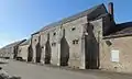 Zehntscheune
 -
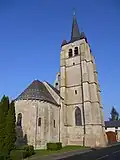 Kirche Saint-Pierre
Weblinks
Commons: Cormainville – Sammlung von Bildern, Videos und Audiodateien