Bransles
| Bransles | ||
|---|---|---|
| ||
| Staat | ||
| Region | Île-de-France | |
| Département (Nr.) | Seine-et-Marne (77) | |
| Arrondissement | Fontainebleau | |
| Kanton | Nemours | |
| Gemeindeverband | Gâtinais-Val de Loing | |
| Koordinaten | 48° 9′ N, 2° 50′ O | |
| Höhe | 77–120 m | |
| Fläche | 13,85 km² | |
| Einwohner | 529 (1. Januar 2022) | |
| Bevölkerungsdichte | 38 Einw./km² | |
| Postleitzahl | 77620 | |
| INSEE-Code | 77050 | |
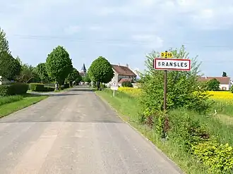 Ortseingang | ||

Bransles ist eine französische Gemeinde mit 529 Einwohnern (Stand: 1. Januar 2022) im Département Seine-et-Marne in der Region Île-de-France. Sie gehört zum Arrondissement Fontainebleau und zum Kanton Nemours.
Geographie
| Chaintreaux | Égreville | |
| Dordives | .svg.png)
|
Chevannes |
| Ferrières-en-Gâtinais |
Sehenswürdigkeiten
Siehe auch: Liste der Monuments historiques in Bransles
- Kirche Saint-Loup-de-Sens (Monument historique)
-
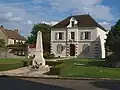 Rathaus mit Kriegerdenkmal im Vordergrund
 -
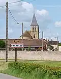 Kirche Saint-Loup-de-Sens
Literatur
- Le Patrimoine des Communes de la Seine-et-Marne. Flohic Editions, Band 1, Paris 2001, ISBN 2-84234-100-7, S. 190–191.
Weblinks
Commons: Bransles – Sammlung von Bildern, Videos und Audiodateien