Boissy-aux-Cailles
| Boissy-aux-Cailles | ||
|---|---|---|
| ||
| Staat | ||
| Region | Île-de-France | |
| Département (Nr.) | Seine-et-Marne (77) | |
| Arrondissement | Fontainebleau | |
| Kanton | Fontainebleau | |
| Gemeindeverband | Pays de Fontainebleau | |
| Koordinaten | 48° 19′ N, 2° 30′ O | |
| Höhe | 71–123 m | |
| Fläche | 16,40 km² | |
| Einwohner | 274 (1. Januar 2022) | |
| Bevölkerungsdichte | 17 Einw./km² | |
| Postleitzahl | 77760 | |
| INSEE-Code | 77041 | |
| Website | https://www.boissyauxcailles.fr/ | |

Boissy-aux-Cailles ist eine französische Gemeinde mit 274 Einwohnern (Stand: 1. Januar 2022) im Département Seine-et-Marne (Region Île-de-France). Boissy-aux-Cailles gehört zum Arrondissement Fontainebleau und zum Kanton Fontainebleau.
Lage
Die Gemeinde liegt im Regionalen Naturpark Gâtinais français.
Nachbargemeinden sind:
| Nanteau-sur-Essonne | Tousson, Le Vaudoué | La Chapelle-la-Reine |
| Buthiers | .svg.png)
|
|
| Amponville |
-
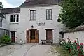 Rathaus
 -
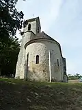 Kirche Saint-Martin
 -
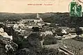 Boissy um 1900
Sehenswürdigkeiten
Siehe: Liste der Monuments historiques in Boissy-aux-Cailles
Literatur
- Le Patrimoine des Communes de la Seine-et-Marne. Flohic Editions, Band 1, Paris 2001, ISBN 2-84234-100-7, S. 136–137.
Weblinks
Commons: Boissy-aux-Cailles – Sammlung von Bildern, Videos und Audiodateien