Availles-Thouarsais
| Availles-Thouarsais | ||
|---|---|---|
| ||
| Staat | ||
| Region | Nouvelle-Aquitaine | |
| Département (Nr.) | Deux-Sèvres (79) | |
| Arrondissement | Parthenay | |
| Kanton | Le Val de Thouet | |
| Gemeindeverband | Airvaudais-Val du Thouet | |
| Koordinaten | 46° 52′ N, 0° 8′ W | |
| Höhe | 62–124 m | |
| Fläche | 10,85 km² | |
| Einwohner | 184 (1. Januar 2022) | |
| Bevölkerungsdichte | 17 Einw./km² | |
| Postleitzahl | 79600 | |
| INSEE-Code | 79022 | |

Availles-Thouarsais ist eine französische Gemeinde mit 184 Einwohnern (Stand: 1. Januar 2022) im Département Deux-Sèvres in der Region Nouvelle-Aquitaine. Sie gehört zum Arrondissement Parthenay und zum Kanton Le Val de Thouet.
Lage
Availles-Thouarsais liegt etwa 26 Kilometer ostnordöstlich von Bressuire und etwa 24 Kilometer nordnordöstlich von Parthenay am Thouet. Umgeben wird Availles-Thouarsais von den Nachbargemeinden Saint-Généroux im Norden, Irais im Nordosten und Osten sowie Airvault im Süden und Westen.
Bevölkerungsentwicklung
| Jahr | 1962 | 1968 | 1975 | 1982 | 1990 | 1999 | 2006 | 2019 |
| Einwohner | 246 | 220 | 224 | 249 | 241 | 223 | 212 | 193 |
| Quellen: Cassini und INSEE | ||||||||
Sehenswürdigkeiten
- Kirche Saint-Hilaire
- Schloss Piogé, Monument historique
-
 Kirche Saint-Hilaire
 -
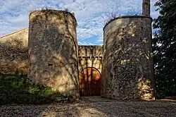 Burg Piogé
Weblinks
Commons: Availles-Thouarsais – Sammlung von Bildern, Videos und Audiodateien