Atuela
| Dilareman | |||
|---|---|---|---|
| |||
| Koordinaten | 9° 0′ S, 125° 21′ O | ||
 | |||
| Basisdaten | |||
| Staat | Osttimor | ||
| Gemeinde | Bobonaro | ||
| Verwaltungsamt | Bobonaro | ||
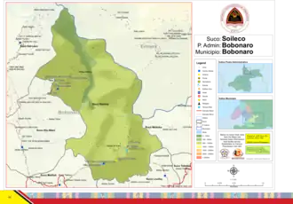
| Suco | Soileco | ||
| Aldeia | Ai-Aras | ||
| Höhe | 752 m | ||

Atuela ist ein osttimoresischer Ort im Suco Soileco (Verwaltungsamt Bobonaro, Gemeinde Bobonaro). Das Dorf liegt im Süden der Aldeia Ai-Aras, auf einer Meereshöhe von 752 m. Eine Straße führt von hier nach Nordosten zum Nachbarort Dilareman und nach Südwesten nach Colobete.[1][2]
Einzelnachweise
- ↑ Direcção-Geral de Estatística: Atlas der Gemeinde Bobonaro ( vom 14. August 2022 im Internet Archive).
- ↑ Timor-Leste GIS-Portal ( vom 30. Juni 2007 im Internet Archive)