Atos (Ort)
| Atos | |||
|---|---|---|---|
| |||
| Koordinaten | 9° 6′ S, 125° 12′ O | ||
 | |||
| Basisdaten | |||
| Staat | Osttimor | ||
| Gemeinde | Bobonaro | ||
| Verwaltungsamt | Lolotoe | ||
| Suco | Gildapil | ||
| Aldeia | Atos | ||
| Höhe | 737 m | ||

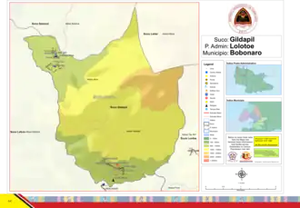
Atos (Atus) ist ein osttimoresischer Ort im Suco Gildapil (Verwaltungsamt Lolotoe, Gemeinde Bobonaro). Das Dorf liegt im Nordwesten der Aldeia Atos, auf einer Meereshöhe von 737 m,[1] zwischen zwei Zuflüssen des Malibaca.[2] Nördlich befindet sich das Nachbardorf Sassa, südlich erhebt sich der Berg Taswa (1301 m). An ihm vorbei führt eine Piste zum Dorf Gildapil.[1]
In Atos befindet sich eine Grundschule.[1]
Einzelnachweise
- ↑ a b c Direcção-Geral de Estatística: Atlas der Gemeinde Bobonaro ( vom 14. August 2022 im Internet Archive).
- ↑ Timor-Leste GIS-Portal ( vom 30. Juni 2007 im Internet Archive)